
| Environmental Commission | |||||||||
| |||||||||
| Local Information | |||||||||||||||
| |||||||||||||||
| Environmental Info | ||||||||||||||||||||||||
| ||||||||||||||||||||||||
The Atlantic Highlands Environmental Commission meets the fourth Tuesday of every month at 7:30 PM at Borough Hall
2021 Environmental Commission Report to Mayor & Council
For Environmental Emergencies: Call the DEP Hotline
1-877-927-6337
Meetings are open to the public
Atlantic Highlands Environmental Commission Members
| Name | Position | Term Expires | |
| Blake Deakin | Regular member & Chair | 12/31/25 | |
| Larry Goldberg | Regular member | 12/31/25 | |
| Morgan Spicer | Regular member Lenape Woods Steward |
12/31/27 | |
| France Karras | Regular member | 12/31/25 | |
| Linda Peng-Grooters | Regular member | 12/31/26 | |
| Brian Dougherty | Planning Board Representative | 12/31/25 | |
| Paul Wright | Regular member | 12/31/25 | |
| Alyson Forbes | Council Representative | 12/31/25 | |
| Jacob Fugger | Alternate member and Waterfront Steward | 12/31/26 | |
| Warren Kotzas | Alternate member | 12/31/26 |
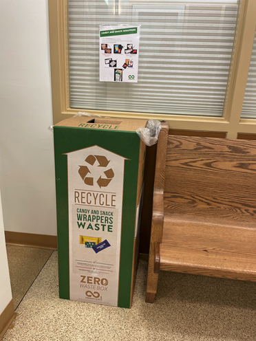
Atlantic Highlands Environmental Commission has sponsored a candy wrapper and snack bag recycling box. Created by the NJ-based company TerraCycle, this innovative solution allows for recycling of wrappers which would otherwise end up as landfill waste. Families are encouraged to save clean wrappers and drop them off at borough hall to be recycled.
Thanks to resident Katrina Majewski for submitting this idea!
